
|
|
Whereas single mission or sensor specific measurements of vegetation index exist, the length of these records is usually limited due to the mission life expectancy, usually few years, engineering and technological changes which necessitates new designs and improvements, and changes in data processing methods and approaches which render the older data undesirable and hard to integrate with newer data. In practice, these limitations impose a restriction on the data usefulness, in particular when addressing long-term phenomenon and trends because they lack representation, or in statistical context, they cannot support the generation of an accurate and representative long-term normal. Extending these records beyond the life span of a single sensor is crucial to remote sensing data.
Three global daily synoptic imagers; AVHRR, MODIS and VIIRS are the current work horse of global land surface vegetation imaging. Up to 1998/2000 AVHHR (N-7, 9, 11, 14) remained the only synoptic remote sensing work horse of Earth Observation, and starting 2000/2002 the records were augmented by data from the much improved EOS MODIS Terra and Aqua (Justice and Townshend 2002; Huete et al. 2002) and to a lesser extend SPOT-VEGETATION (VGT). These records are now being replaced by the operational S-NPP VIIRS and eventually by the Joint Polar Satellite System (JPSS) VIIRS instrument (Fig. 1). The merits of these systems lie in their time-series of daily multi-spectral observations, which are used to characterize and monitor the land surface at regional to global scales. While not all land products have their heritage in the NOAA-AVHRR, the Vegetation Index data record dates back to 1981 when NOAA’s Advanced Very High Resolution Radiometer (AVHRR) started this continuum (Tucker et al. 2005; Brown et al. 2006). This vital VI Earth science record supports monitoring, detecting, and quantifying global land vegetation properties.

Figure 1. Current single sensor data records
To support across sensor data continuity, VIIRS VI data was compared to AVHRR and MODIS records.
The sensor land cover based data cross correlations show strong and consistent linearity (R2>95%., Fig 2), which indicates that VI are for the most part readily interchangeable requiring minor continuity adjustment (Didan et al. 2016).
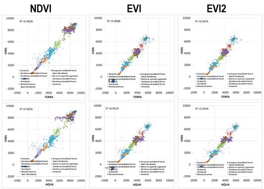
Figure 2. Land cover dependent across sensors VIs correlation
Using the VIIRS/MODIS 2012-2015 overlap data a prototype explicit pixel based monthly continuity transfer maps were developed (Fig. 3) between VIIRS and MODIS (and AVHRR not shown). These transfer maps can be used to translate the VI data cross the two sensors, following equation:

Figure 3. Prototype explicit seasonally dependent per pixel transfer function/map continuity algorithms for VIIRS to MODIS
